For a while now I’ve been enjoying the ability to export ham radio logging data from Ham Radio Deluxe Logbook direct to Google Earth for visualisation of my contacts. However now that I have some far reaching contacts, Google Earth no longer presents a full view of radio coverage:
 What I’d like to do now is be able to plot the same data onto a Great Circle projection map, centered on my home location to present a view of radio contacts’ direction and distance. A friend (with a specialism in Geographical Information Systems, GIS) has pointed me at the open source QGIS software. Some light reading around the subject suggests that I basically have two tasks to perform:
- Import the data as a Vector Layer into QGIS;
- Change the project’s Coordinate Reference System (CRS) to a great circle type projection, centred on my location.
Importing Data to QGIS
Free world map data is available here: http://www.naturalearthdata.com/ …download suitable files and import appropriate shapefiles (.shp) as new vector layers.
Export selected contacts from HRD Logbook to Google Earth (right-click, “Lookup…”) opens an exported KML file in Google Earth and the contact data appears in Google Earth’s “Temporary Places” folder. The unmodified KML file doesn’t appear to import correctly into QGIS (the folder structure that is generated by HRD Logbook’s export seems to mask the contents) but the individual points and lines can be moved to a single new folder in Google Earth (without their individual folders) and this will save as a KML file that does import nicely into QGIS:
A slightly hacky way of making the HRD0Logbook output KML file readable by QGIS is to use a text-based ‘find and delete lines’ routine to remove the folder structure which seems to be the problem.
Notepad++ is a good tool for this kind of work. Open up the KML file and go Search, Find… open the Mark tab and check the Bookmark line box. Now do a Mark All for the terms “folder” and “All”. This will bookmark the lines that are to be removed. Now back the the menu bar, Search, Bookmark -> Remove Bookmarked Lines. Now save the modified KML file and this should import nicely into QGIS:
 So now I can get all of my contacts data input to QGIS from HRD Logbook without too much fuss…
Creating a Great Circle (Azimuthal Equidistant) Map
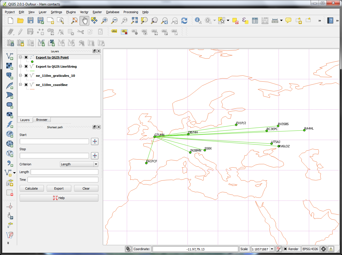
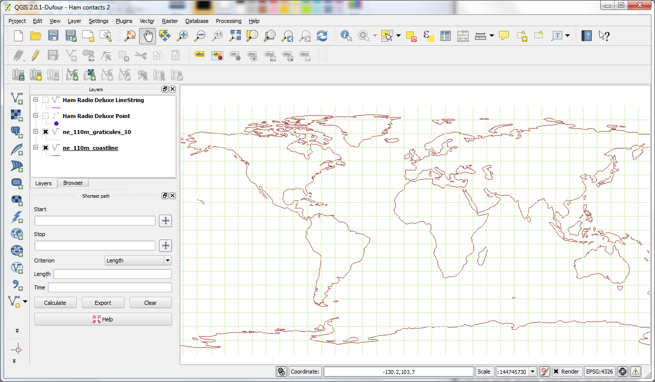
Importing a basemap shapefile or two from Natural Earth is pretty easy and gets you a world map in the standard WGS84 projection (here I have a coastline layer and a 10° graticule layer):
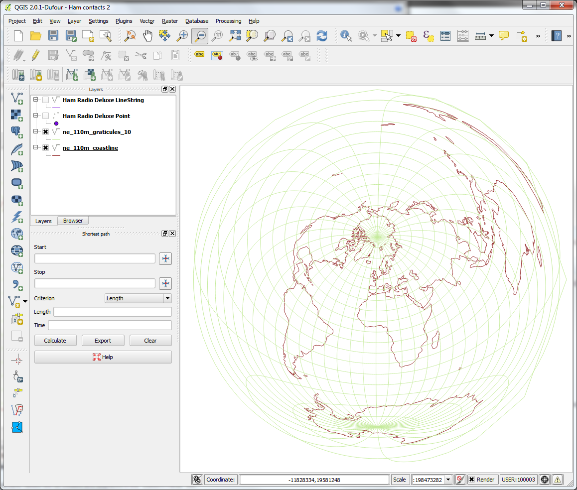
The next thing to do is to change the Coordinate Reference System (CRS) from WGS84 (the “normal” but distorted view we’ve come to expect from world maps) to a great circle projection, centered on my location (approximately 51°N 1°W). My initial mistake here was to search with the terms “great circle QGIS” and this brought me lots of information about plotting great circle route lines but not maps. I realised “great circle” is a fairly ambiguous phrase which is used in varying ways in the GIS community. Changing the search terms to a more precise “azimuthal equidistant QGIS” quickly yielded guidance on the projection I was looking for.
In QGIS go Settings, Custom CRS… and create a new user defined CRS using the following parameters:
+proj=aeqd +R=6371000 +lat_0=51 +lon_0=-1
…where my location is 51°N 1°W, enter your lat/long figures accordingly. This gives me the result I’m after:
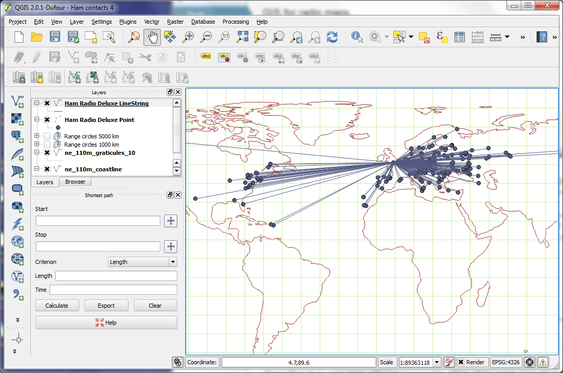
 Right, next thing I need is radials and range circles…
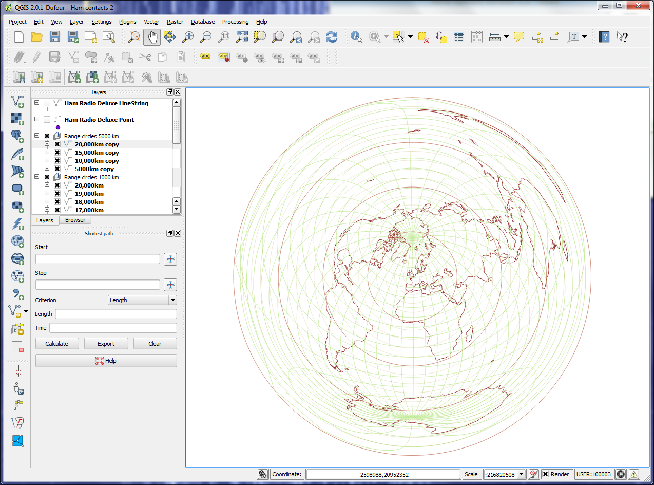
Range Circles
I’m sure there’s an easier way to do this directly in QGIS with buffers but here’s one simple method (and probably easier to understand for a GIS n00b like me). This online tool creates KML files of circles of a given radius and centre. They don’t seem to import straight into QGIS as vector layers but they do open in Google Earth and that allows me to group them into a Places folders and export as a KML file that imports as vector layers (a bit laborious but only needs to be done once for any given location):
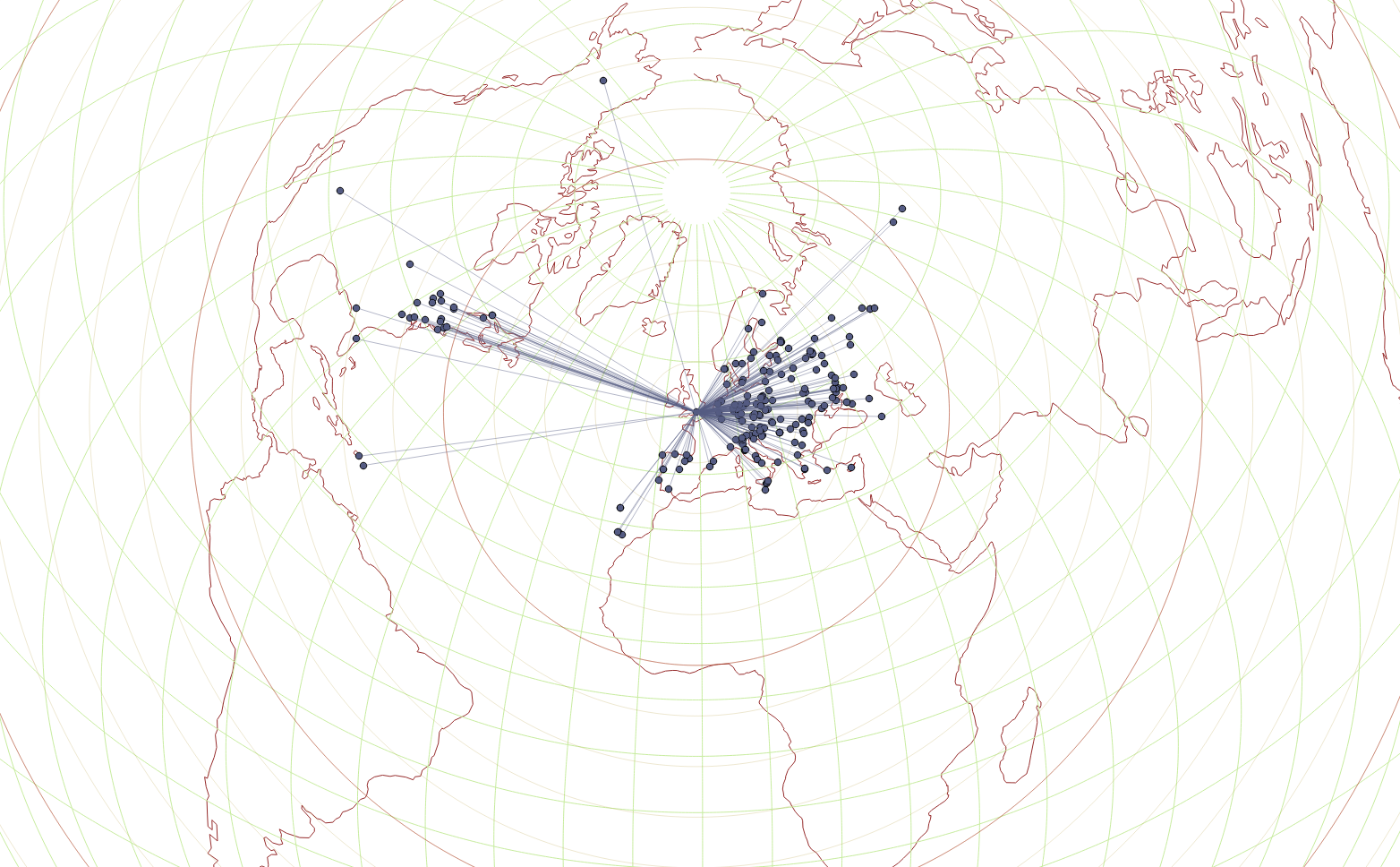
 I’m currently looking for a way to draw some radial lines with their origin at my location…
Results
So, all this allows me to plot radio contacts on a great circle type map and helps me relate coverage to antenna configuration, operating frequency, etc…
 The use of a GIS for this task gives a great deal of flexibility on the look and feel of the output which is quite exciting and something I shall be experimenting with. 🙂